
When the Tubbs Fire swept through Camp Newman on October 8, 2017, it took with it decades of memories—cabins, gathering spaces, the physical heart of a beloved community. But in the ashes, we saw a different kind of opportunity: to rebuild with fire wisdom, not fire fear.
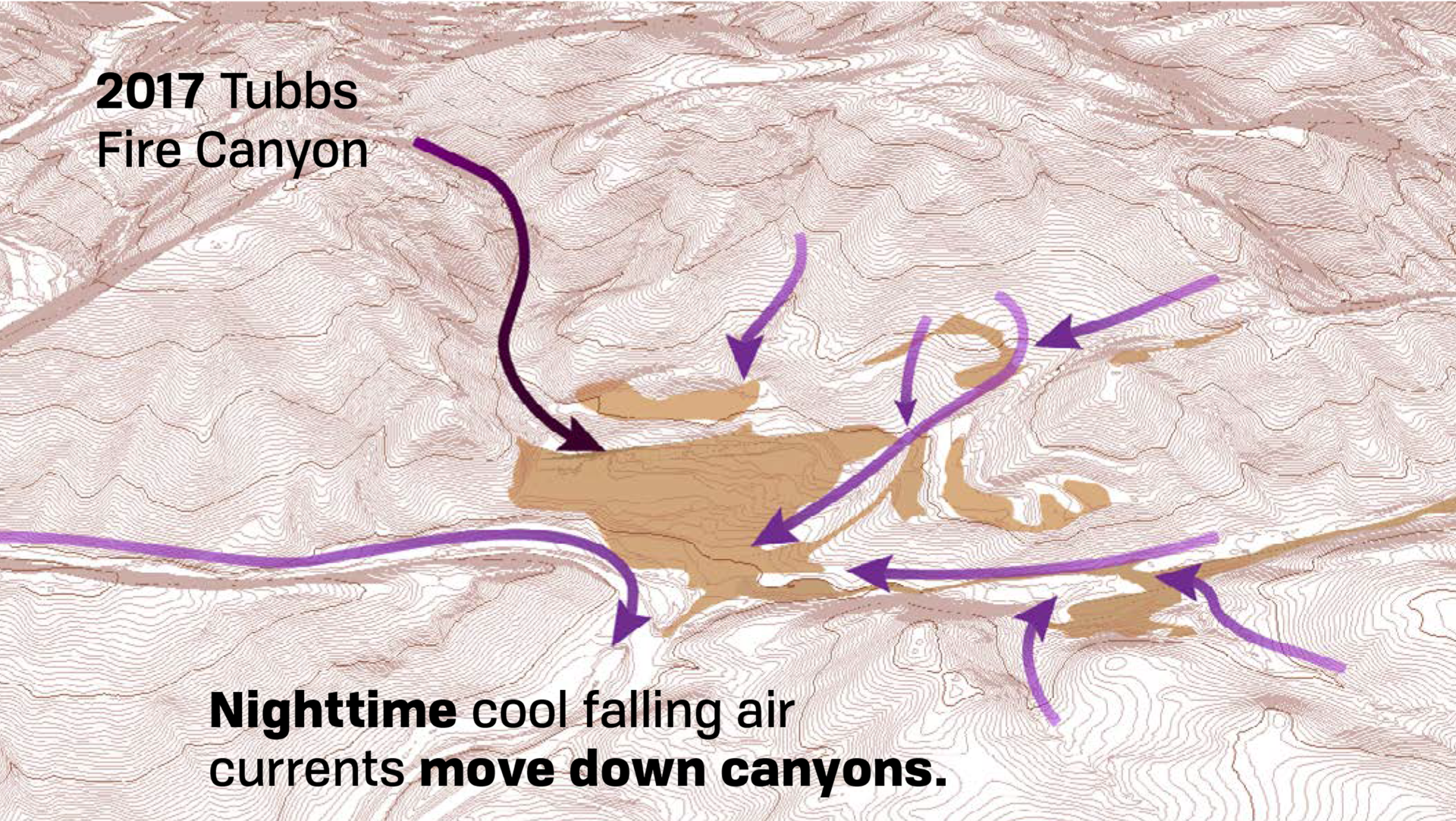
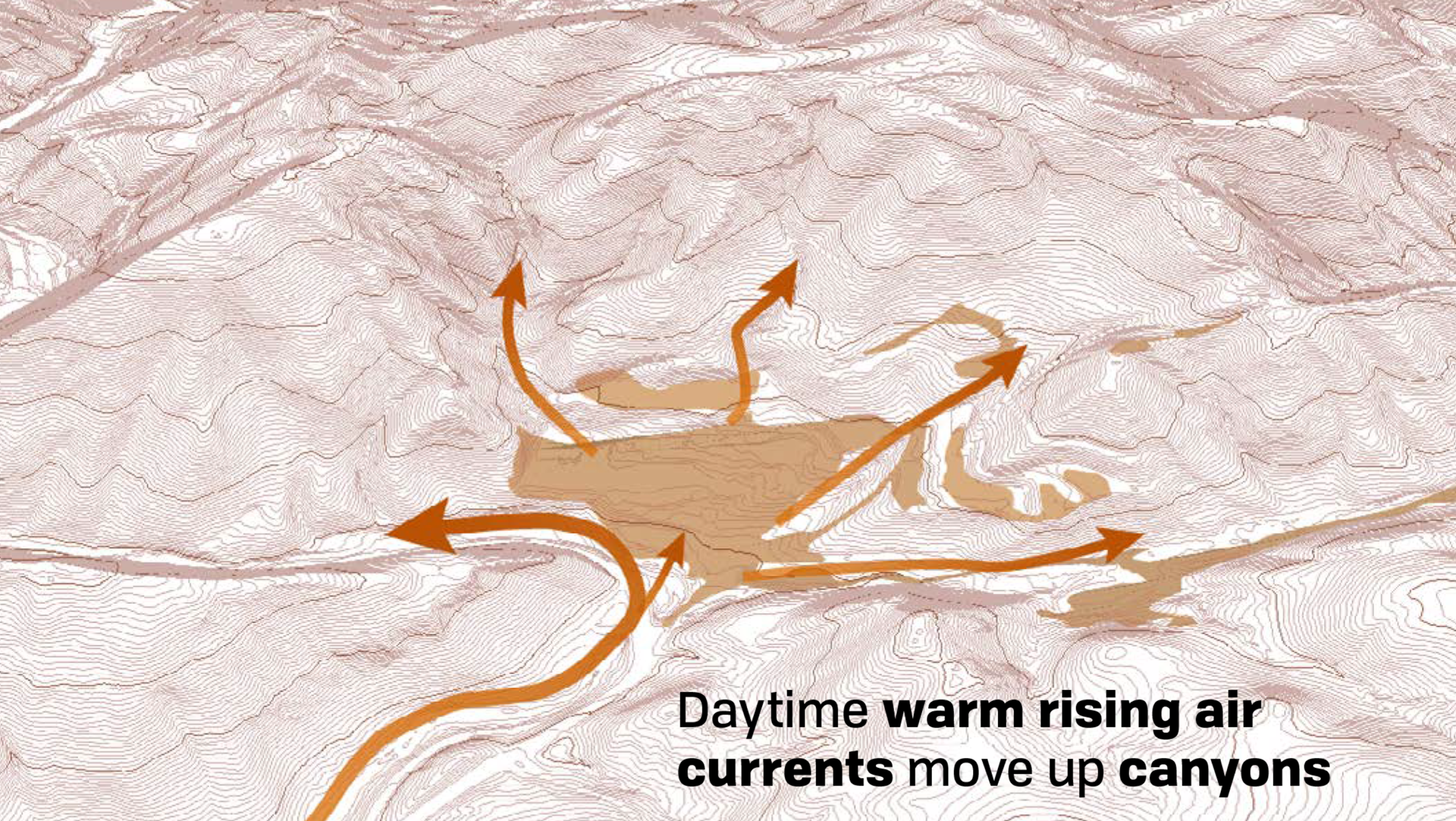
Working with Siegel & Strain Architects and UC Berkeley fire ecologist Joe McBride, we began by studying how fire actually moves. We modeled wind patterns racing up ridgelines, mapped how flames jump between fuel sources, and identified the critical moments where a fire’s path can be redirected rather than simply resisted. Understanding fire behavior became our design compass.
The strategy wasn’t about building fortresses—it was about choreographing the landscape to work with fire’s natural rhythms. We created meadow buffers that slow flame spread, thinned oak woodlands to reduce fuel ladders, and positioned the rebuilt campus where topography naturally disperses fire intensity. Open plazas double as community gathering spaces and fuel breaks. A restored creek system weaves through the site as both ecological amenity and fire barrier.
Every design decision asks: How does fire want to move here, and how can we gently redirect it?
Camp Newman now welcomes 700 campers and retreat guests to a landscape designed for California’s fire future—a place where safety and ecology, resilience and beauty, aren’t competing goals but integrated realities.
Size
Size 25 acres – core development area, 450 acres – total property
Client
Camp Newman URJ
Team
Siegel + Strain (Architect)
Oberkamper (Civil)
Pieter Colanbrander (MEP)
Joe McBride (Forestry Fire Consultant)
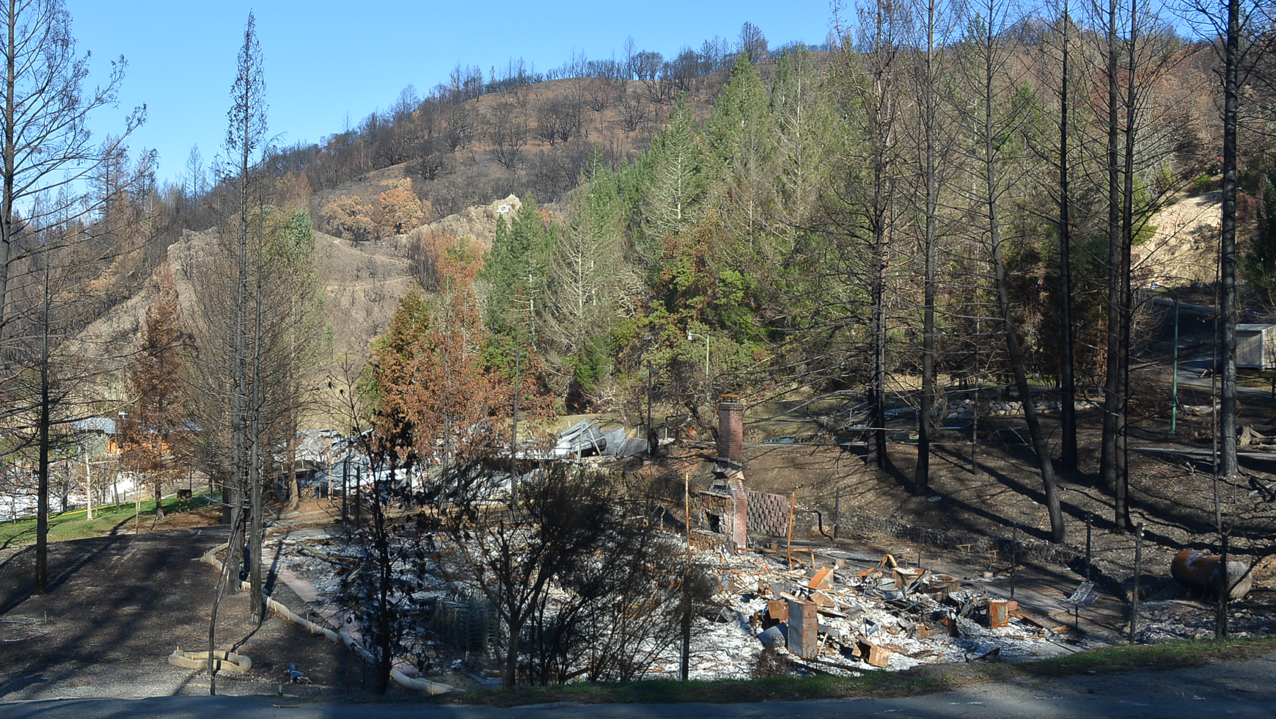
When the Tubbs Fire swept through Camp Newman on October 8, 2017, it took with it decades of memories—cabins, gathering spaces, the physical heart of a beloved community. But in the ashes, we saw a different kind of opportunity: to rebuild with fire wisdom, not fire fear.
Working with Siegel & Strain Architects and UC Berkeley fire ecologist Joe McBride, we began by studying how fire actually moves. We modeled wind patterns racing up ridgelines, mapped how flames jump between fuel sources, and identified the critical moments where a fire’s path can be redirected rather than simply resisted. Understanding fire behavior became our design compass.
The strategy wasn’t about building fortresses—it was about choreographing the landscape to work with fire’s natural rhythms. We created meadow buffers that slow flame spread, thinned oak woodlands to reduce fuel ladders, and positioned the rebuilt campus where topography naturally disperses fire intensity. Open plazas double as community gathering spaces and fuel breaks. A restored creek system weaves through the site as both ecological amenity and fire barrier.
Every design decision asks: How does fire want to move here, and how can we gently redirect it?
Camp Newman now welcomes 700 campers and retreat guests to a landscape designed for California’s fire future—a place where safety and ecology, resilience and beauty, aren’t competing goals but integrated realities.
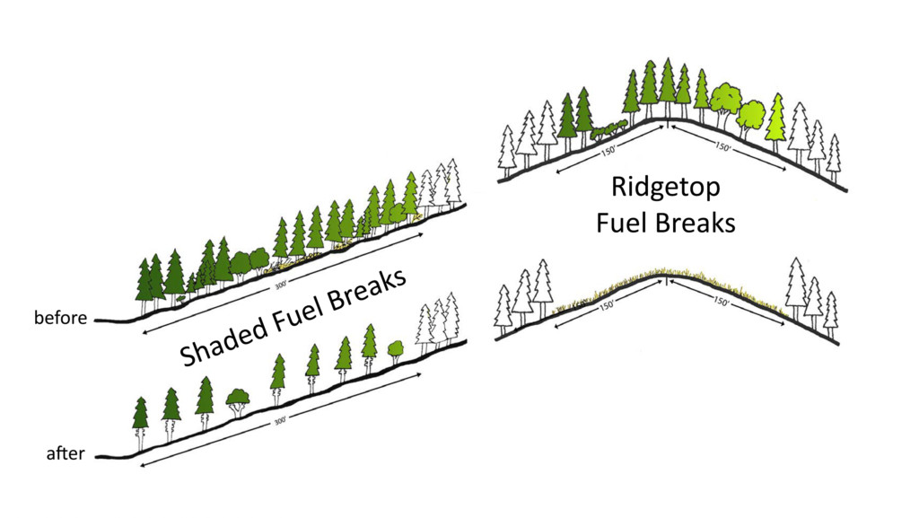
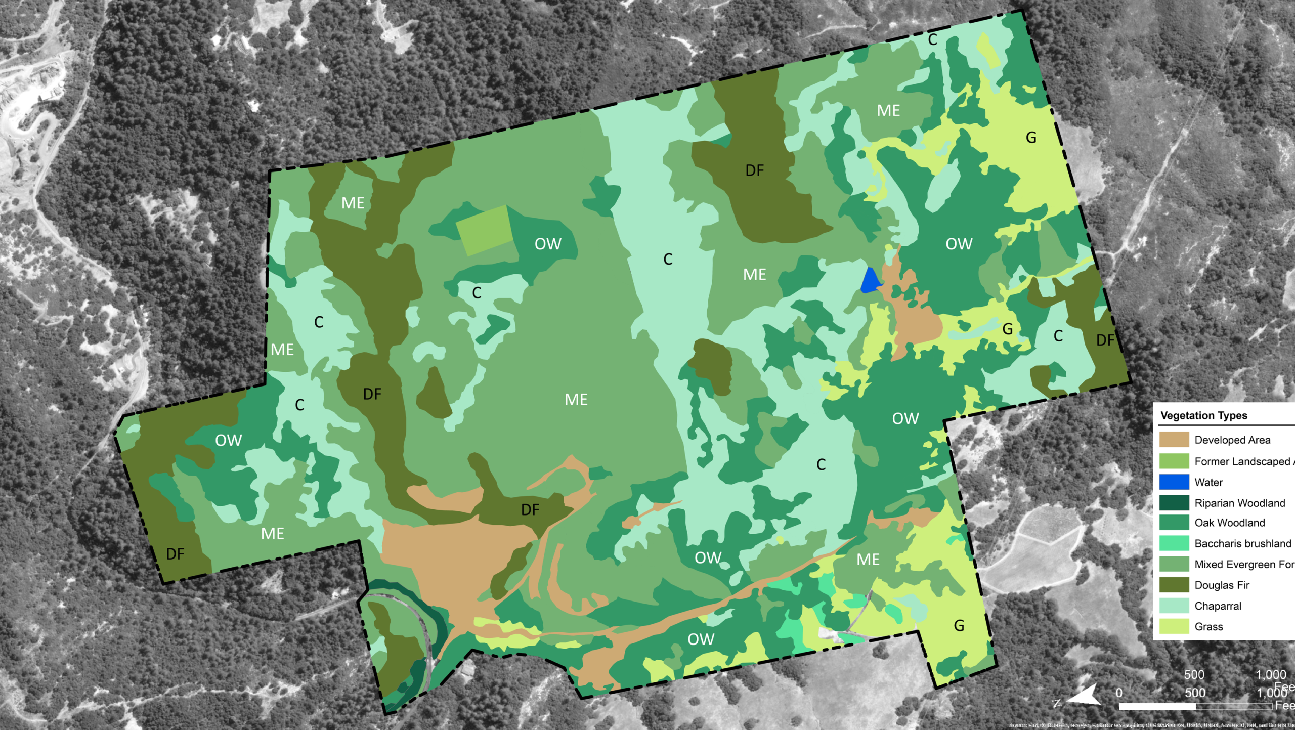
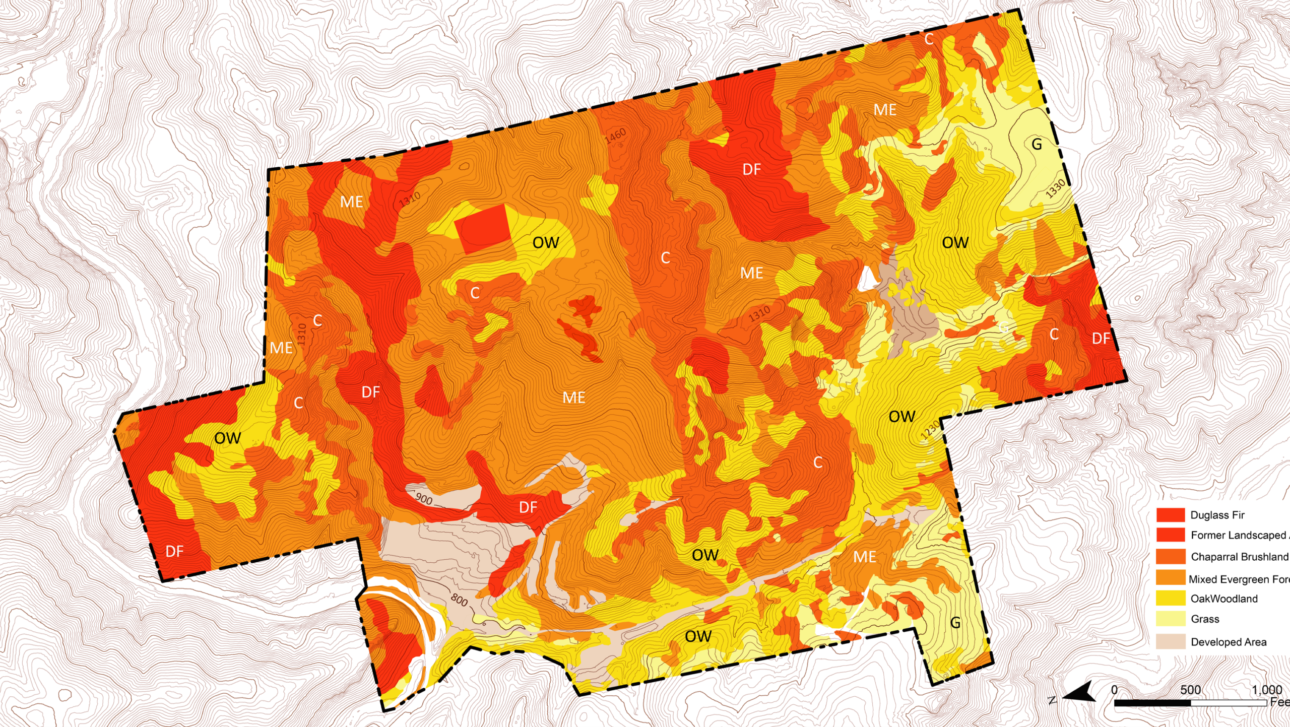
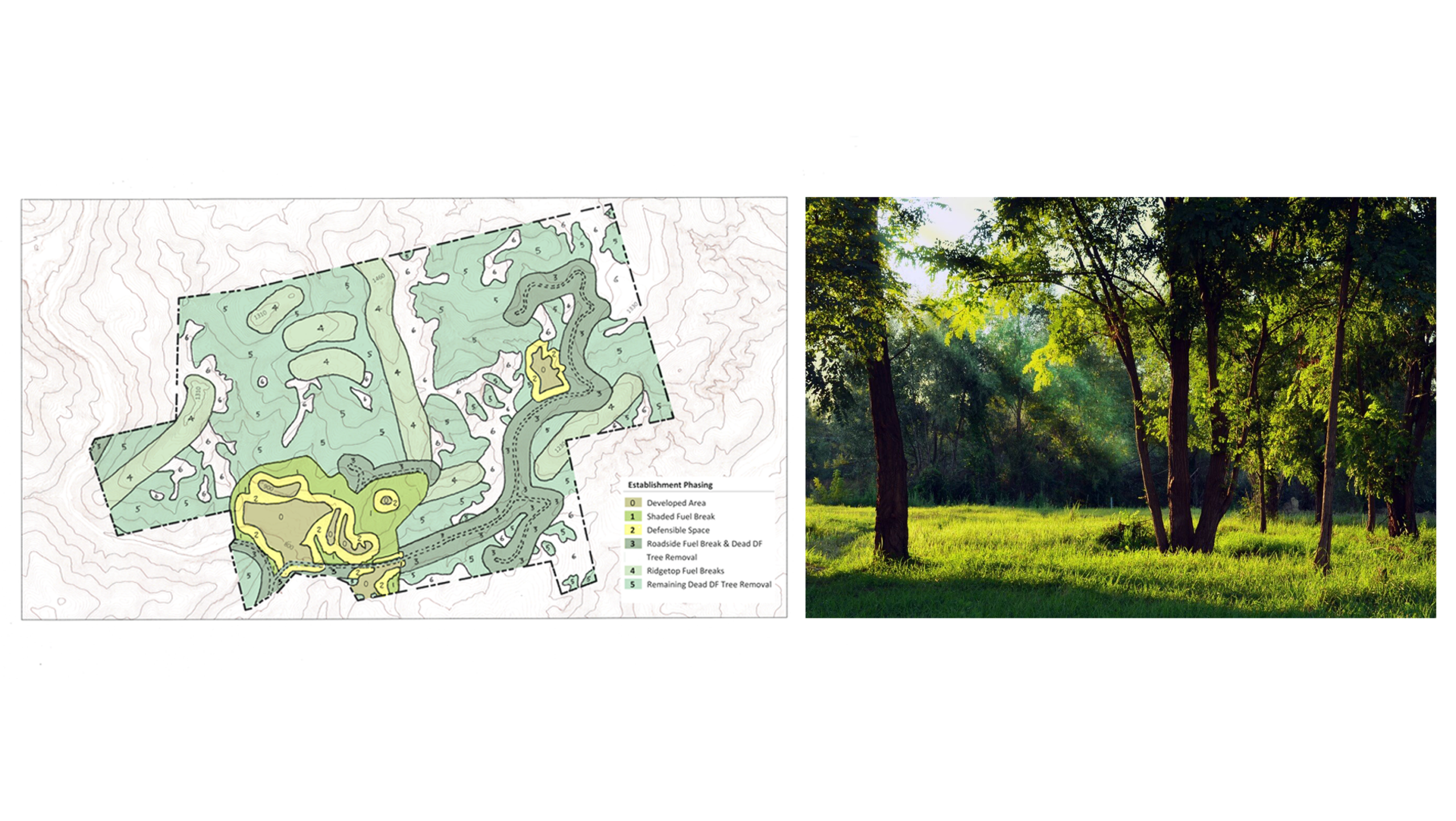
The Camp Newman Fire Adaptation Plan employs three primary fuel break strategies, each calibrated to specific topographic conditions and fire behavior patterns. Fire-adaptive management strategies include cleaning understory, thinning trees, and selecting species for fire resistance.
Shaded Fuel Breaks on Slopes Mid-slope fuel breaks interrupt vertical fire progression without creating full canopy removal. We selectively thin understory vegetation and remove ladder fuels while retaining 30-50% canopy cover to prevent erosion and maintain forest health. Spacing between retained trees follows the 10-foot rule (crown separation = 10 feet + 10% of slope gradient), creating discontinuous fuel arrays that slow upslope fire movement while preserving the ecological and visual character of forested slopes.
Ridgetop Fuel Breaks Ridgelines concentrate wind-driven fire intensity and serve as natural firebrand launching points. Our ridgetop fuel breaks extend 100-150 feet on either side of the ridge crest, with more aggressive thinning (60-70% canopy removal) to account for extreme wind exposure and ember transport potential. These zones prioritize fire suppression access and create anchor points for backfiring operations during active fire events.
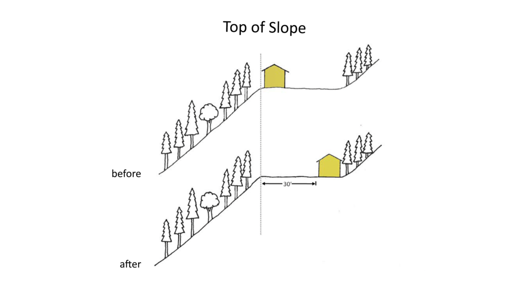
Top-of-Slope Infrastructure Buffers Where buildings occupy ridge or upper slope positions, we establish 100-foot defensible space zones that transition from highly managed (0-30 feet: irrigated, low-fuel landscaping) to moderately managed (30-100 feet: thinned natives, fuel load <3 tons/acre). These buffers account for radiant heat exposure, ember accumulation in building corners, and the reality that upslope fires arrive with maximum intensity. Infrastructure placement prioritizes ridgetop locations specifically to avoid mid-slope fire chimneys and vegetation funnels.
© All rights reserved WiLD LandArch